
The Sammamish River Story
History Snippet
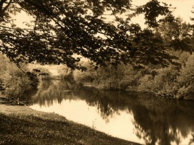
Before Woodinville had roads, railroads, farms, or wineries, the winding waterway called Squak Slough – now the Sammamish River – was the valley’s first highway. It carried Indigenous travelers, the Woodin family, steamboats, logs, livestock, and farm goods—and later became a roaring racetrack for tiny hydroplanes traveling more than 50 miles per hour. Today’s quiet, straightened Sammamish River gives little hint of the wild, twisting waterway beneath Woodinville’s story.
The Full Story…
Hold On—Here Comes Another Boat
Picture the Sammamish Slough on an April morning nearly seventy years ago.
People are crowded along the riverbanks and leaning over bridges. Farmers have wandered over from nearby fields. Somewhere in the distance comes the high-pitched roar of an outboard motor.
Then a tiny plywood hydroplane appears.
It shoots around a bend, bounces across another boat’s wake, narrowly misses a bridge piling—and disappears around the next curve. Another boat follows. Then another.
Sometimes they made the turn.
Sometimes they did not.
A boat might skid onto the muddy bank, become tangled in brush, or sail completely out of the water and into a farmer’s field. Spectators did more than watch. They helped right overturned boats, pull racers from the mud, and push damaged craft back into the river.
For almost half a century, this narrow waterway between Lake Washington and Lake Sammamish hosted one of the region’s strangest and most thrilling sporting events: the Sammamish Slough Race.
But the racers were only the latest travelers to discover that this river could be beautiful, useful, unpredictable—and very difficult to navigate.
To understand why anyone would race a nine-foot boat through its sharp turns, we need to go back to a time before Woodinville existed.
First, There Was the River
The river came before Woodinville had streets, bridges, farms, wineries, or even a name.
Today, the Sammamish River travels approximately 14 miles from Lake Sammamish to Lake Washington, passing through Redmond, Woodinville, Bothell, and Kenmore.
It looks peaceful and remarkably orderly.
The river known to earlier generations was neither.
It twisted back and forth across the valley through forests, wetlands, marshes, islands, and side channels. Some estimates suggest that its wandering course was once nearly twice as long as the channel we see today.
It flooded the valley, carried salmon, nourished wetlands, and determined where people could travel and live. Later, it would move settlers, mail, lumber, livestock, furniture, farm produce—and racing boats.
Woodinville grew around the river and then spent more than a century trying to control it.
A Road, a Food Source, and a Gathering Place
Long before settlers arrived, the river and the lakes it connects were part of the homelands of Coast Salish peoples.
These waterways linked villages, fishing places, gathering grounds, and travel routes throughout the Lake Washington and Lake Sammamish region. Cedar canoes carried people, food, tools, materials, and trade goods between communities.
The river provided access to salmon, waterfowl, berries, cedar, wapato, and other important resources. It was not simply a blue line running through the landscape.
It was a road.
It was a source of food.
It was a place of gathering, movement, and connection.
Those relationships continue through the Snoqualmie Indian Tribe, Muckleshoot Indian Tribe, and other Coast Salish communities whose histories, cultures, and treaty-protected fishing and gathering rights remain central to the river’s story and future.
A River With Several Names
Nineteenth-century settlers commonly called the waterway Squak Slough.
“Squak” was an English attempt to record an Indigenous place name associated with the people and waterways near present-day Issaquah. Because English speakers wrote Native words as they heard them, the name appeared in several spellings.
The name Squak Slough can be found in newspaper accounts from the 1870s. Sammamish Slough and Sammamish River began appearing in print by the 1890s.
For years, all three names were used.
Squak Slough gradually fell out of common use during the 1920s, although longtime residents continued calling it that well into the twentieth century. Many people still affectionately call the river “the Slough” today.
The word slough might make it sound like a quiet swamp or forgotten backwater.
It was anything but.
For the people trying to reach the upper valley, it was the main route between two enormous lakes.
The Woodins Come Around the Bend
In 1871, Ira and Susan Woodin set out for their new homestead.
There was no road leading to their claim. There was no railroad station waiting for them. There was not yet a town called Woodinville.
The family loaded its belongings onto a flat-bottomed scow, crossed Lake Washington, and entered Squak Slough.
The boat had no engine. Progress required rowing, poling, pulling, and plenty of patience. The water could be shallow, and the river’s endless bends made the journey much longer than it appeared on a map.
Susan Woodin later remembered how difficult the trip had been. Ira reportedly joked that the slough was so crooked that travelers could pass the same tree several times while still trying to get around one bend.
At last, the family reached its 160-acre claim along the river.
Their home became much more than a family residence. It served as a stopping place for travelers and settlers, and the Woodins’ home and store became part of the center of the small community growing around them.
That community eventually took their name: Woodinville.
The Woodin family did not simply settle near the river. They arrived because of it.
The Valley’s First Highway
For Woodinville’s earliest families, the river was the road.
Scows and shallow-draft steamboats carried passengers, groceries, mail, furniture, machinery, livestock, and building materials. Farmers sent milk, fruit, vegetables, and other products toward larger markets. Logs from the surrounding forests traveled downstream.
Almost anything needed in the valley arrived by water—or left that way.
Travel was rarely easy.
Boats encountered fallen trees, sandbars, low water, overhanging branches, floating debris, and corners sharp enough to test even an experienced boat captain.
Still, Squak Slough connected the settlements that became Redmond, Woodinville, Bothell, and Kenmore. Homes, farms, stores, and mills appeared near the river because that was where people, supplies, and news arrived.
A river that looks like a boundary to us today once tied the entire valley together.
The Railroad Arrives—and the River Loses Its Job
During the 1880s, transportation in the valley began to change.
The Seattle, Lake Shore & Eastern Railway reached the Woodinville area in 1887 and 1888. Trains gave farmers and lumber companies a faster, more dependable connection to Seattle.
In 1889, the Stringtown Bridge provided an important crossing over Squak Slough. Emanuel Neilsen reportedly built the bridge using an ox-powered pile driver of his own design.
Imagine that for a moment: an ox helping drive bridge pilings into the riverbed while trains began arriving nearby.
Woodinville’s transportation system was changing quickly.
Roads and additional bridges followed. The river remained important, but it was no longer the valley’s only highway.
People also began to look at it differently.
When boats had been the primary form of transportation, the waterway’s depth and flow were essential. Once travel moved onto roads and rails, its bends, marshes, and seasonal floods began to look less like natural features and more like problems waiting to be fixed.
Farmers Versus the Slough
The Sammamish Valley contained exceptionally fertile soil.
Unfortunately for farmers, much of that soil was frequently underwater.
The river regularly overflowed its banks, spreading across fields and wetlands. Landowners dug drainage ditches, removed logjams, dredged shallow areas, and searched for ways to move water out of the valley more quickly.
Efforts to modify the waterway were underway by the 1890s, when shallow-draft steamboats still traveled between the two lakes.
In 1912, local farmers funded a major project to dredge and straighten portions of Squak Slough between Redmond and the Woodinville area.
The reasoning seemed simple: fewer bends would allow water to move faster. Faster water would improve drainage. Better drainage would make more of the valley available for farming.
The project worked—but not without a cost.
As sections of the river were straightened, natural curves, pools, wetlands, and side channels began to disappear. These places had slowed floodwater and provided habitat for fish and wildlife.
The river was becoming more useful to agriculture but less like the river it had once been.
Then Lake Washington Dropped Nine Feet
An even greater change came in 1916 with the opening of the Lake Washington Ship Canal and Ballard Locks.
Lake Washington dropped by approximately nine feet.
That dramatically increased the elevation difference between Lake Sammamish and Lake Washington. Water began moving more quickly through the slough. Shorelines shifted, wetlands receded, and additional valley land dried out.
The transformed landscape became home to dairy farms, vegetable fields, berry farms, poultry operations, nurseries, and flower growers.
The broad agricultural valley remembered by generations of Woodinville residents was not simply discovered beneath the water. It was created through decades of dredging, draining, digging, and reshaping.
The river had once decided where people could live.
Now people were deciding where the river would go.
And Then Someone Decided to Race on It
Even after dredging and straightening, the Sammamish Slough remained narrow, shallow, and filled with troublesome turns.
Naturally, someone looked at it and thought: This would be an excellent place for a boat race.
The organized Sammamish Slough Race began in the spring of 1928 and became an annual April tradition. The original course followed the waterway between Lake Washington and Lake Sammamish, covering roughly 13 to 14 miles in each direction.
That meant racers faced a round trip of nearly 28 miles.
This was no smooth, open-water speedway. One historical account describes a course with 63 sharp turns, along with bridge pilings, sandbars, floating logs, shallow water, muddy banks, and plenty of opportunities to leave the river unintentionally.
The drivers raced small outboard boats and hydroplanes that seemed almost absurdly tiny for the challenge ahead.
The boats bounced over wakes, slid around corners, dodged debris, and competed for space in a channel that was barely wide enough for calm traffic—much less a pack of racers trying to reach the same bend first.
It was noisy, smoky, fast, unpredictable, and irresistible to spectators.
Woodinville Gets a Front-Row Seat
The races became one of the Eastside’s biggest annual attractions.
Spectators gathered along bridges, roads, farms, and riverbanks in Kenmore, Bothell, Woodinville, and Redmond. People watched from wherever they could find a view.
The action came remarkably close.
There were no grandstands separating the crowds from the course. Boats screamed past only a short distance away. Photographers positioned themselves near difficult turns, hoping to capture a spin, collision, or spectacular landing in the mud.
A 1949 British newsreel treated the race as equal parts competition and comedy. Its footage showed racers flying around bends while nearby farms—and at least one unimpressed cow—carried on as usual. Boats left the water often enough that the narrator joked about competitors continuing their journeys over land.
For racers, however, landing in a field was not particularly funny.
Propellers broke. Engines failed. Boats overturned. Drivers hit logs, bridge pilings, sandbars, and riverbanks. Competitors carried spare propellers, shear pins, and tools because finishing the race often required roadside—or riverside—repairs.
Spectators frequently joined in, helping to lift boats, turn them upright, and push them back into the water.
The race was part sporting event, part endurance test, and part community rescue operation.
Nine Feet of Plywood at Fifty Miles an Hour
One of the race’s best-known competitors was Bob Wartinger.
Wartinger entered his first Sammamish Slough Race in 1963, before he was even old enough to have a driver’s license. He had built his own nine-foot plywood hydroplane at his family’s home in Shoreline.
Getting the boat to the starting line in Kenmore required help from a friend who was old enough to drive.
Once on the water, Wartinger raced at more than 50 miles per hour.
He did this while rounding sharp bends, passing bridge pylons, watching for logs, avoiding other racers, and trying to keep his homemade boat in the river.
Before the race, an experienced competitor gave the teenager valuable advice: take the trip toward Lake Sammamish carefully, survive the hazards, and then race whoever remained on the return journey.
That was not excessive caution.
Depending on conditions, between half and two-thirds of the field might be eliminated by crashes, breakdowns, debris, or encounters with the riverbank before completing the first leg.
Wartinger followed the advice and finished third in his first race.
He returned every year until the event ended and became one of its most successful competitors. He later built an international racing career and set a world outboard speed record of 170 miles per hour.
But before the records and worldwide competition, there was a homemade plywood boat, a borrowed ride to Kenmore, and one of the twistiest waterways imaginable.
The River Gets Another Makeover
Despite years of drainage work, the Sammamish Valley continued to flood.
During the early and mid-1960s, King County and the U.S. Army Corps of Engineers undertook a much larger flood-control project.
The river was widened, deepened, and straightened again. Old bends and side channels were cut off. A control structure was built near the Lake Sammamish outlet at Marymoor Park to regulate water levels and flow.
The project reduced flooding and protected farms and property.
It also changed the race.
The new structure near Lake Sammamish prevented boats from completing the original course all the way to the lake, forcing organizers to shorten the route.
The environmental effects were even more lasting.
Shaded banks, wetlands, deep pools, woody debris, and cool side channels disappeared. These areas had provided shelter and resting places for salmon and other wildlife.
The river became more efficient at moving water.
It became less effective at supporting the diverse life that had once depended on its slower, messier, more complicated form.
The Last Race
As the years passed, the boats became faster—but the narrow river did not become safer.
The final Sammamish Slough Race was held in April 1976.
During that race, an out-of-control boat struck and injured a spectator. Afterward, organizers were unable to secure affordable insurance to continue the event.
After 48 years, the Sammamish Slough Race came to an end.
The outboard engines fell silent.
The crowds disappeared from the bridges.
The farmers no longer had to wonder whether a hydroplane might suddenly arrive in their fields.
But for those who saw the races, the memories remained: the smell of two-stroke engine oil, the roar of boats approaching around a bend, the crowds lining the banks, and the suspense of waiting to see which drivers would return—and which ones might need help getting out of the mud.
A Quieter Kind of River Traffic
The Sammamish River is no longer Woodinville’s commercial highway or high-speed racetrack.
Today, people move beside it on the Sammamish River Trail. Walkers, runners, cyclists, and strollers have replaced freight wagons and railroad cars. Kayaks, canoes, paddleboards, and rowing shells have replaced steamboats and racing hydroplanes.
Herons stand along the banks. Eagles circle overhead. Beavers, otters, ducks, and other wildlife continue to use the river corridor.
The peaceful landscape can make its dramatic history difficult to imagine.
Look closely, however, and signs remain.
The straight banks reveal the work of dredges and engineers. Low areas mark former channels. Agricultural fields occupy land that was once part of the river’s floodplain. The trail follows a transportation corridor that gradually replaced the waterway itself.
And beneath that calm surface is the memory of small plywood boats tearing through Woodinville at more than 50 miles per hour.
Helping the River Recover
The Sammamish River remains essential habitat, but the changes that made the valley easier to farm and develop created lasting environmental challenges.
Much of the channel has little shade, allowing summer water temperatures to rise. Warm water can be dangerous for migrating salmon. Low summer flows, invasive plants, development, and the loss of wetlands and side channels place additional stress on the river.
Chinook, coho, sockeye, kokanee, steelhead, and trout all depend on the larger watershed.
Tribes, King County, cities, farmers, environmental organizations, and community groups are now working to restore portions of the river. Their efforts include planting native trees, improving shade and cool-water habitat, reconnecting wetlands and side channels, and finding better ways to manage flooding.
The river will never look exactly as it did before settlement. Too much of the valley has changed.
But portions of its natural character can return.
The River Running Through Woodinville’s Story
Woodinville would not exist in the same way without this waterway.
Indigenous communities traveled, fished, gathered food, and maintained cultural connections along it.
The Woodin family arrived on it.
Settlers used it as a highway.
Farmers depended on it—and fought its floods.
Engineers shortened and straightened it.
Racers challenged every turn that remained.
Today, trails follow it, wildlife depends on it, and restoration projects are helping parts of it recover.
Its name has changed from an ancestral waterway to Squak Slough, Sammamish Slough, and finally the Sammamish River.
Its shape has changed even more.
Yet the river continues to run through the center of Woodinville’s story—sometimes quietly, sometimes wildly, but never without leaving its mark.
Sources and Further Reading
- Woodinville Heritage Society historical records and timeline.
- Feliks Banel, “Thrilling Boat Races Once Ran on the Sammamish Slough,” MyNorthwest, April 14, 2023.
- Eastside Heritage Center, “The Sammamish Slough Races.”
- Redmond Historical Society, “Sammamish Slough Races.”
- Kenmore Heritage Society, “Sammamish Slough Then and Now.”
- Snoqualmie Indian Tribe, Lake Sammamish Story Map.
- HistoryLink, Jennifer Ott, “Woodin Family Crosses Lake Washington to Homestead on Squak Slough.”
- Washington State Department of Ecology, Sammamish River Temperature and Dissolved Oxygen Study.
- King County, Sammamish River Capital Investment Strategy.
- King County and U.S. Army Corps of Engineers, Sammamish River Corridor Action Plan.
 When the Valley Turned Purple